EASTER WEEKEND, 2002: ALL OVER OKLAHOMA
18 APRIL 2003
Scott Kampas,
Mark Sefried, and I met in St. Louis and tried our hand in NE Kansas on Friday 4-18,
telling ourselves that it was "on the
way to Oklahoma" where Saturday's setup drew crowds from around the country. Kansas gave us
a cap bust and we headed for Oklahoma hoping for better fortune.
April 18th
continues my long luckless streak with Kansas convection.
19 APRIL 2003
We spent Friday
night in Perry, Oklahoma. With a perfect
crystal ball, we might have stayed right there and let the storms come to us. We noted dramatically low cloud bases in northern
Oklahoma on our way toward OKC, but I believe aggressiveness pays off and wanted to be
near the dryline for any early initiation, as many believed would occur.
We talked about what the morning's showers might have done to the
cap. As it turned out, we should have talked
about how the rain affected instability, and how those weakened values delayed initiation.
As we drove
southwest on 44, we noted a windshift trend ahead of the dryline: a discouraging
southwesterly swing, bringing slightly cooler
air. We debated if this feature was a
pre-frontal trough or an outflow boundary; either way it played havoc with our surface
setup.
We stopped south
of Chickasha and met with Eric Nguyen, Jeff Lawson, and Scott Currens. During the course of the day, Scott Kampas talked
with Blake Naftel, Chris Novy, Colin Davis, and others who provided information. Robert
Hall, Steve Miller, and Mike Hollingshead also provided good nowcasting and observations
during the event.
Noting a line of
cu forming west and northwest of OKC, apparently along a northerly outflow boundary, we
headed back north on 44, the first of the day's many loops, circles, figure eights, and
pirouettes. We cut across to Moore and turned
north on I-35.
At Guthrie, we
turned west on State Road 33 and drove to Cedar Valley where the towers that Mike
Hollingshead was observing near Kingfisher
encountered our windshift and frayed, sending us racing back east on 105 for Chandler,
Oklahoma. Chasers there reported convection forming on the convergence northeast of the
dryline bulge.
We fueled in
Chandler and cruised toward TUL on 44 while two low-topped supercells formed on either
side of the highway, following our course
toward the city. We stayed on 44 since this
allowed us to keep pace with both storms, though the northern cell assumed a more
northerly track.
We closed on the
southern storm after hearing the tornado reports near Slick then Mounds (both apparently
false, we learned later). This storm held a
better position relative to surface flow. We
also considered that the southern storm might seed its northern twin, something that didn't happen because the northern
storm turned nearly due north as it entered Tulsa county.
So we dove into
the TUL metro area, not my preferred strategy. What
can I say? We'd thrown ‘the book’
out the window.
In the thick of
suburban south Tulsa, we turned onto 64/51, exited onto N Aspen, and turned south. One half mile south of Highway 51, we
stopped and watched the storm approach from the southwest,
our view obscured by trees and buildings.
A Doppler radar towered in the distance.
We turned west
onto W Kenosha planning to hit State Road 64 south for a better view to the southwest when confusion at the intersection convinced us to
reverse course. The storm had a more easterly component now. Afraid of falling behind or getting into the core,
we made a U-turn on W Kenosha and headed due east.
We spotted the
wallcloud in the rearview mirror near the intersection of Kenosha and N Aspen, directly
west of our location. This ragged feature grew as we sought a place to stop and observe.
We continued
east on Kenosha then north onto N Redbud, stopping
on the small neighborhood road where a young girl in a blue dress, about seven years old,
appeared at the passenger window and asked if we were stormchasers. Her parents and other
siblings huddled in the doorway of their house across the street. They waved as a new
tailcloud whipped and snapped beneath the weak mesocyclone.
The wallcloud organized and disintegrated several times, rotation distinct on video. We viewed this feature from N36 03.758' W95 48.669' looking due west at 5:00 PM Central time.
With no eastern
route in this neighborhood, we turned back south and then east again on W Kenosha. We
turned N on N Elm and observed a much higher and unremarkable rain free base.
We headed south
on 51 for a stab at the McAlester storm, but soon heard reports of it weakening. We knew the game was up.
Heading home, we
coursed through northwest Arkansas into Missouri on narrow back roads, passing the
Bentonville capital of the Republic of
Wal-Mart, and dodging a Pomeranian dog, two possums, one coyote, and two goats (one gray
and one white-- see image by Scott Kampas). Mark Sefried drove us safely through this
wildlife tour. No injuries on either side.
20 APRIL 2003
On Sunday
afternoon, I arrived back in Bloomington, Indiana at the same time as a severe storm which
produced two inch hail downtown. I tried to
get a view of the storm, but the terrain here is rolling forest. I settled for filming the brightly-lit backside of
the updraft tower from the Sears parking lot in the mall.
2100 miles and
three days later, my cats are still alive and the class I thought I'd missed was
cancelled, I learned after sifting through
170 emails.
FOGEY-ISTIC BLATHER
I'm intrigued by the tornado controversy and think about how much pressure there is to see tornadoes, and how some chasers define success of failure strictly in these terms.
We also have new economic pressures.
Tour groups advertise and sell their guides' ability to find tornadoes, and the video
market is more competitive than ever. When
tornadoes become an economic commodity, a
form of currency, it's no wonder that their appearance is more hotly debated.
When I started chasing in late 1996,
this idea wasn't so dominant. One could
declare a chase successful and fun based entirely on structure and other features (even
regional or roadside interests!), and not get laughed out of the room.
I admit being as caught up in the new
tonal shift as anyone. I wonder where it will
take us and how much satisfaction and potential enjoyment newer chasers lose in the
rancor,

April 18th near Manhattan, Kansas @ 4:15 PM

The coolest sign of the year.

Still in Kansas. Towering cumulus.
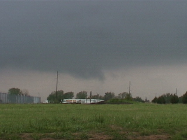
April 19th: Southeast Tulsa @ 5:00 PM
looking due west from North Redbud Road

Same a few moments later

April 20th: west side of Bloomington, Indiana
@ 7:00 PM looking up the side of the tower.
Two inch hail reported at this time.

April 20th: east central Bloomington as
storm races into Brown County @ 7:23 PM

April 20th: northwest Arkansas. Wild goats.
Image by Scott Kampas.