From Lockhart looking NW at Tornado 1 at 3:58PM

Zoom of Tornado 1 with funnel extending from out of ragged condensation, barely visible above stop sign

Now end of funnel can be seen extending from left telephone poll back into ragged condensation cloud

Rope funnel visible above stop sign

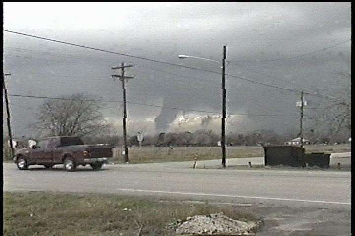
Tornado #1 still visible and Tornado #2 visible just to the left of far right telephone poll

Funnel of Tornado #1 re-organizes while Tornado 2 moves just to the left of far right telephone poll
I spent Christmas week in Albuquerque with friends and flew to Dallas Sunday for the second week of Christmas vacation. Checking data at the airport, I suspended my plans and drove a rented Blazer to College Station for the night, positioning myself for Tuesday. In the morning I used the pristine local CLL public library and noticed that the West Texas vortmax had slowed and was digging more deeply than progged on prior model runs.
An early morning shortwave passed through SE Texas and subsidence behind the disturbance began clearing the skies. A patch of sunshine opened between thin convection along a pre-frontal trough and the actual front. This area moved east from the I-35 corridor and was growing.
This was the first of a few factors that reminded me of 10-9-2001 in Southern Oklahoma, when early showers moistened the BL and contributed perhaps to even lower LCLs. On Tuesday as well, the early clouds (our 'three o'clock cu' appeared at noon) were very low and encouraging. I suspected that with the low bases and impressive low level shear, given the almost certain appearance of secondary sfc lows, weak brief spinups were possible in the area.
Noting the more SE-ly winds and a tongue of higher dewpoints from Victoria to near Austin, I repositioned to Bastrop, just east of Austin. Cloud bases here appeared somewhat higher and the town is nestled in a pine forest, so I didn't want to stay long. Dave Fick arrived soon after and loaned me a video camera and a 2 meter HT since my chase gear remained safely stowed in my truck parked at the Indianapolis airport. Who knew, right?
Dave and I noted a mesolow forming SW of SAT near the Rio Grande and then moved to San Marcos when a storm near Hondo gained some vigor and cruised in our direction. Behind it the squall line was growing and we knew the window for isolated storms would remain open only briefly.
By the time we intercepted the storm west of San Marcos it had already produced one tornado and earned two warnings. South of town I caught sight of the first of several large wallclouds, then discovered I was too close and escaped to the east on Highway 80 toward Lockhart.
Reaching town around 3:52 I turned back to the west and watched the storm approach Lockhart with a cylindrical lowering and scud growing beneath. Within seconds these joined and a crisp elephant trunk tornado was on the ground.
Strangely, from my position it was difficult to discern the funnel's rotation, and I told Dave Fick on the cellphone moments later that it "looked" like a tornado but that I wasn't sure. As it turns out, the sharp eyes of Steve Miller and Eric Nguyen later revealed from the video that two tornadoes were present on this storm, the first being closer to me, and the second nearer the interface of the rain and RFB. This second tornado is likely the same one photographed more clearly by Carson Eads.
On the video, watch carefully as the dark, cone moves behind the
telephone pole on the far right of the frame. I'm on the phone at the time, and have
some instinctive sense that something is reorganizing over there (which is why I keep
panning over there), but didn't detect it at the time.
I continued chasing from Lockhart to near Giddings where the storm was finally ingested by
the line.
This was a great chase for renewing my love of Texas and the ubiquitous geography of her
South Central regions. I owe a huge thanks to Dave Fick for the loaned gear and to Jeff
Gammons and Steve Miller for several critical nowcasting calls.
On to 2003!
Amos Magliocco KC5VPD